GPS systems available locally
Published: Sunday | March 8, 2009
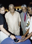
Winston Sill/Freelance Photographer
Executive director of Mona GeoInformatics Institute, Dr Parris Lyew-Ayee (left), and colleague Keisha Josephs (right) show off the features of the GPS system to (from second left) Robert Pickersgill, Professor E. Nigel Harris and Dr Elizabeth Ward, at the launch of Jamaica's first GPS navigation system. The event was held at the Senior Common Room, University of the West Indies, Mona campus, last Thursday.
Brian Bonitto, Editor - Overseas Publications
ARE YOU unsure of your destination but need to get there on time? Forget the cumbersome road maps or the need to ask directions: just plug in your coordinates and drive.
That's how easy it is, courtesy of the Global Positioning Satellite (GPS) navigation system.
The technology was introduced to Jamaica at a function held on the grounds of the Senior Common Room at the University of the West Indies (UWI), Mona campus, last Thursday.
Head of the project, Dr Parris Lyew-Ayee, was very upbeat about the practicality and purpose of the device.
"It's user-friendly and for anyone who can get lost," he said. "Housewives can use it ... expatriates and diplomats, tourists, taxi men and auto dealers ... "
Safety aspects
Lyew-Ayee, who is the executive director of Mona GeoInformatics Institute, highlighted the safety aspects of the gadget as well.
"We have preprogrammed the system to avoid crime hot spots," he said. "Let's say you're in Kingston and want to reach Ocho Rios ... while going through Spanish Town would be the shortest route ... the system would give the Spanish Town bypass as the option."
GPS system was developed by the United States Department of Defense and was intended for military use. It, however, went worldwide in the 1980s. The technology enables GPS receivers to determine their current location, the time, and their velocity.
According to a UWI press release, the system features 10,000 Jamaican roadways and 69 categories, including police stations, attractions, banks, post offices, gas stations and restaurants.
"It also features cemeteries, churches and dental offices," he added.
The executive director said that the multimillion-dollar project took two and a half years.
Outside work
"The project was funded from money we generated by doing work outside," he said. "We then reinvested it into the research and development of this project."
But will this technology take off locally?
"The possibilities are endless," the executive director said. "Business cards will have your GPS coordinates, so too party promotions will have coordinates ... there will also be opportunities for importers of the device."
How do you go about getting this thing?
"If you possess the device (GPS), all you need to get from us is the chip ... and this costs US$115," he said. "One cost, no set-up fee, no monthly fee."
Lyew-Ayee said that the device can give directions in various languages, which includes French, Chinese and Portuguese.
"The Jamaican accent is coming," he said.
Distributed by JAA
The Jamaica Automobile Association (JAA) is now distributing the devices on which the map of Jamaica will be loaded in a partnership arrangement. Fidelity Motors, distributors of Nissan, will provide the system as well as a tracking device free with any purchase of a vehicle before the end of this month.
If there are no major potholes for Lyew-Ayee's project, questions such as 'Are we there yet?' may be a thing of the past.