Beach Rock on the Palisadoes
The worst hurricane on record appears to be that of 1722. It lasted 14 hours, raised a five-metre storm surge in Port Royal, made that town an island again, and created five breaches or channels through the eastern part of the Palisadoes. It is possible to overlay a map made in 1722, right after the storm, on a modern map of Palisadoes. The positions of the five breaches of that map can then be compared with today's conditions. The positions of the breaches correspond to anomalies in the water depths on the harbour side of the Palisadoes. It is tempting to suggest that these anomalies may represent the remains of washover sand and gravel from the 1722 hurricane, dumped in the harbour, much like the new beaches created by Ivan.
The westernmost breach of the five appears to have been the most serious one. It persisted for some time and was reopened as late as 1782. Its site today is at one of the narrowest parts of the Palisadoes, A series of groynes was constructed here in the 1950s, but are now in a very poor state of repair. The washover that occurred on July 7th, 2006 almost exactly marks the spot of that fifth breach. If the 1722 hurricane put 5 metres of water in Port Royal, where wave energies are comparatively low and there is some reef protection, even from the south, it is not surprising that the eastern Palisadoes had holes eroded in it.
Storm damage
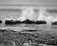
Nevertheless, this same narrow, eastern stretch of the Palisadoes has proved to be surprisingly resilient to storm damage. Even the oldest maps show it to be the same shape as it is today. Why is this so? Because no investigation by drilling has been done as yet, we have no direct information on what this eastern part is made of. It cannot just be loose sand and gravel, for this would have moved and changed shape over time. One possibility is that the sediments of this stretch have become cemented naturally to form Beach Rock, a material that resembles concrete. This would certainly resist erosive processes. Much of the modern beach contains layers of tough beach rock along the seaward shore of the Palisadoes in this area. Perhaps the most prominent example is the beach rock exposure that has been used as a foundation for the limestone boulders that were placed as a, hopefully, temporary form of protection for the narrow part of the peninsula. We say temporary, because there is ample evidence from other sites we have surveyed along the Jamaican coastline that a storm equal in intensity to Ivan would probably move many of those boulders and put them right in the middle of the roadway.
We have thus far made note of three times when the Palisadoes became an island. Join us for the next article, September 14, 2006, in the Hazards of the Jamaican Coastline series when we outline how the Palisadoes probably formed from string of cays, and how it might develop in the near future.
Website http://www.mona. uwi.edu/geoggeol/MGU/
E-mail mgu@uwimona.edu.jm We would like to take this opportunity to indicate that last week's articles were substantially taken from the following sources: http://www. mona.uwi.edu/chemistry, http://en. wikipedia.org, http://users.visi.net/