Edward Robinson, Deborah-Ann C. Rowe, Shakira A. Khan, Contributors

This is the first in a series of articles on Hazards of the Jamaican Coastline contributed by the Marine Geology Unit, Department of Geography and Geology, University of the West Indies. The Unit is headed by Emeritus Professor Edward Robinson.
In the wake of the passage of Hurricane Ivan on the weekend of September 11th, 2004, many people have raised concerns about the viability of the Palisadoes road as a reliable, all weather access to the Norman Manley airport.
By the end of Ivan's passage, among other effects, it had completely blocked the road from Kingston to the airport with sand and stones and, at the height of its passage, raised a storm surge that completely overrode large sections of the eastern part of the Palisadoes, depositing the "new beach" debris fans into the harbour. So, as the waves covered sections of the road, for a few hours, the Palisadoes became an island.
Only the other day waves, pushed by strong winds and high tides, overwashed the narrowest part of the peninsula again, moving sand and stones from the bank at the roadside, leaving debris scattered across the road. For some observers these events beg the questions: "Was the Palisadoes ever an island?
Will it become one in the future? Will further erosion breach the Palisadoes for good and prevent access to the airport"?
The following account should help readers to answer these questions.
The Palisadoes by any other name
To hazard a guess at what will happen to the Palisadoes tomorrow, one needs to know how it got to the stage it is at today. So, first of all, what is or are the Palisadoes?
Here we have a strip of land, some 14 km long, that almost completely encloses Kingston Harbour. In the Oxford Dictionary the word Peninsula is described as "a piece of land almost surrounded by water or projecting far into the sea", so the Palisadoes may be described as a peninsula. However, the more technically minded persons among us like to define the Palisadoes on the basis of some of its physical properties. Some scientists have called it a SPIT while others have called it a Tombolo.
A Spit is defined as a long narrow bit of land made up of beach sediment carried by ocean currents beyond the main shoreline, so that one end of a spit is attached to the shore and the other sticks out into a large body of water. The Palisadoes certainly resembles such a configuration.
A Tombolo is a bar or spit of sand linking an island to the mainland or to another island, usually forming on the sheltered side of the island. Whether the Palisadoes can be called a tombolo or not depends on whether or not it joins the mainland, at Harbour View, to an island. But which island? The history books tell us that Port Royal was once an island, so that, as Port Royal is now joined to the rest of the Palisadoes, it may also be correct to call the Palisadoes a tombolo. So, we leave it up to you, the reader, to decide on which term you prefer.
Semantics aside, the Palisadoes is much more complicated than a simple peninsula, spit, or tombolo would be, for reasons connected with its evolution over the past 5000 years.
Natural Processes Maintain the Palisadoes
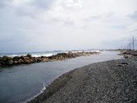
Two major natural processes have come together to build up the Palisadoes. These are the wave action on the coastline and the way fresh sediment is supplied to the coastline. Firstly, ocean waves, breaking on the beaches, are moving the beach and nearshore sand and gavel onto and off the beach every minute of every day. When the weather brings rough waves, the beaches tend to be eroded. In periods of calm weather they tend to rebuild. Also, because the dominant waves approach from the Southeast, they attack the beaches at an angle. This generates currents near the coastline which move the beach sediment gradually westward along the shore. In this way beach sand that may have been near Harbour View many years ago might now have moved as far as Plumb Point lighthouse and beyond. In time to come it will probably reach Port Royal.
This movement of sediment from east to west does not occur at a steady pace. During stormy periods the energy of large breaking waves is able to move large sized pebbles and boulders, whereas in times of calm seas longshore movement of sand predominates and the whole process of transport along the shore is slower. On stretches such as that fronting the airport, the waves approach the beach and carry sediments in and out at right angles to the shore. Along here too, the wind had generated sand dunes that were up to 5 or 6 metres high before Hurricane Ivan.
This longshore drift of sediment to the west is a good thing. It is what keeps the Palisadoes in being as a dynamic system. But if this is a continuing process, where do fresh supplies of sediment come from at the Harbour View end? Without new sediment, the Harbour View end of the Palisadoes would gradually be eroded away and eventually disappear. In other words, there would be no through road to the airport any more. The necessary sand and gravel is brought to the coast by the rivers to the east of the Palisadoes, particularly the Hope River and Cane River, and probably also the Chalky River. As it reaches the coast, some of the river sediment is carried west, by longshore drift, to supply the Palisadoes. In this way the equilibrium between demand and supply is maintained.
The stability of the Palisadoes, then, depends on the arrival of fresh, river-produced sediment from the east. Any interference in this supply could ultimately jeopardise the integrity of the peninsula and the airport road.
Destructive Events
These are mainly tropical cyclones, with earthquakes playing a locally important, but infrequent role. There are several good write-ups of the 1692 earthquake, as well as accounts of the subsequent history of Port Royal. Because the rest of the Palisadoes was either a preserve of the military or was more or less uninhabited until the advent of the airport in 1939, much less is known about the effects of destructive events on the peninsula.