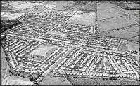
An aerial view of Independence City, one of the Portmore sub-divisions after construction. The low-lying communities that comprise the municipality are flood prone. - File Each year, many communities across the island are severely affected by flood waters. The causative factors are both man-made and natural. In a series of articles, The Sunday Gleaner's investigative reporter Mark Titus takes an in-depth look at flood-prone Jamaica.
EVEN AS a study conducted by the Ministry of Mining confirms the vulnerability of a number of its communities, Mayor of Portmore Keith Hinds says the municipality is not prepared for a disaster.
This, he says, is due to the failure of central Government to provide adequate funding for the suburban community to get ready for the 2008 hurricane season.
"All we have received from central Government is $8 million, and this is completely inadequate," Hinds tells The Sunday Gleaner. "The municipal engineer, in checking our major drains, gave us an estimate of J$68 million for our drain-cleaning project."
While Portmore does not have the problem of improper farming and poor land-mining practices as is the case in some rural parishes, the major drains that are to take the water out of the municipality should there be a flood, are in need of immediate attention, Hinds says.
"We have, in my estimation, approximately 400,000 citizens living in Portmore, and the truth of the matter is that should a disaster strike Portmore, it is not the minister or the municipality who is going to be held responsible, it is the mayor," Hinds argues.
Drain cleaning
"We have already dedicated $5 million to the cleaning of our smaller drains, but the state of our major drains is creating some anxiety. As a result, I have written a letter to Minister of Transport and Works Mike Henry, seeking his assistance to get the work done," the Portmore mayor discloses.
"It would not be fair for us to shoulder the responsibility of the National Works Agency (NWA), and in truth, we are not in a position to do so," he states. "As far as it appears, we are expected to finance central Government's responsibilities, and this cannot happen."
However, communications manager at the NWA, Steven Shaw, informs The Sunday Gleaner that the $8 million that was given to the Portmore municipality was a fraction of the NWA's budget of $77 million for its national disaster-mitigation project and that a request has been made for additional resources.
"We have completed phase one of the national mitigation programme, which we embarked on in May of this year. We have also made a request for additional funds and will soon begin work on phase two of the drain network, not just in Portmore, but across the country," Shaw explains.
According to the works agency's spokesman, the mitigation programme is priority, as the longevity of the nation's roadways, is heavily dependent on a proper drainage system. Other activities which complement the alleviation exercise include the cleaning of side drains and culverts.
The study 'Natural Hazard and Risk Assessment for Portmore, St Catherine' shows that Portmore, and specifically, the communities of Waterford, Caymanas Gardens, Independence City and Westchester, are at risk of flooding, storm surges and seismic activity.
location and flooding
The study was prepared by the Government's mines and geology division in collaboration with the Office of Disaster Preparedness and Emergency Management (ODPEM). Funded by the United Nations Development Programme it shows that the municipality of Portmore is prone to flooding due to its location on the Rio Cobre flood plain.
"Portmore has a history of inland and coastal flooding from storm surges," states Norman Harris, director of research and mapping at the mines and geology division. "Many storms that pass through the island begin their entry along Portmore's south coast. Also, an increasing number of persons are at risk, as Portmore is the fastest-growing community in the island."
When The Sunday Gleaner visited the municipality, there was evidence that some work had been done. However, of the neighbourhoods mentioned in the study, only Westchester had begun its drain-cleaning exercise. Other areas located along the coast line such as Edge Water, Bridgeport, Port Henderson and Passage Fort are also considered defenceless against any natural disasters, yet no work has been done in these districts.
Seventeen shelters are available in Portmore if a disaster occurs, with Portsmouth, Gregory Park and Southborough primary schools, along with Ascott High and the Portmore Heart Academy being the priority shelters. The municipality also has 35 trained shelter managers on call.
Ronald Jackson, director general of the Office of Disaster Preparedness and Emergency Management, points out that with the study completed by the mines and geology division, there needs to be a revision of the Portmore evacuation plan.
The study points out that due to its coastal location on the south of the island, Portmore is vulnerable to storm surges, especially along the shoreline communities of Hellshire and Port Henderson. Earthquake activity is also a strong possibility.
issue of access
"My biggest concern for Portmore is the density, the issue of access," he states, "What we are going to have to do is look at how we can enhance our evacuation plan with some additional detail, looking at the various hurricanes and storm-surge probabilities, including the storm-surge heights that can affect the coast line and how far inland they will break. Then we will be able to fine-tune our evacuation process so that we can deal with the movement of people efficiently, effectively, and help to secure the communities and return people afterwards," Jackson says.