Mona Institute of Applied Sciences (MIAS), Eye on Science, Palaeoseismology, Contributor
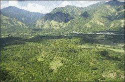
St Thomas plains (foreground) with mountains in the background. The Plantain Garden Fault lies within the mid-ground of this photo.
In science there are a number of words that begin with the prefix palaeo- (English) or paleo- (North American) such as palaeomagnetism, palaeontology, palaeoclimate, and paleoseismology. Synonyms of palaeo- are old, ancient and pre-historic. Palaeoseismology is the science of finding past earthquakes, the art of literally uncovering when and where ancient earthquakes occurred and the likely magnitudes of the events.
Given the late 20th-century surge in instrumental detection, recording and analysis of earthquakes, and remote-sensing methods, it is interesting that seismology had to revert to basic arduous and dirty geological field work, albeit with a difference, for some of the most pertinent discoveries on earthquake recurrence and seismic hazard, which indeed no modern seismogram can disclose. Emerging only in the last 20 or so years of the 20th century the scientists who specialise in such work are palaeoseismologists, essentially geologists trained to look for ancient earthquakes in the walls of trenches dug across or along fault lines.
The first step
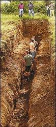
Trench exposing sediments across a terrace riser at Serge Island.
The first step in any palaeoseismic study involves searching for suitable places to dig. Digging is expensive in cost and time, and not possible nor practical everywhere along the fault. It is therefore worth the time and effort to study the area very carefully using small scale maps, aerial photographs, Google Earth and even fly-overs in light aircraft or by helicopter, anything that gives a good view of the terrain and helps to narrow the search for prospective successful trench sites. What exactly is one looking for? Faults when they move, particularly in larger earthquakes, offset topographic and riverine features like spurs and ridges and river terraces, creating risers and notches and other distortions of the land. Once these features exist at the surface, the underlying layers should show corresponding disruptions. Geologists infer what the subsurface looks like by mapping rock types and attitudes at the surface. Palaeoseismologists conduct digs, much like archaeologists, to expose relics of fault activity. Dating of carbon samples and sediments taken from the trench are used to constrain the age of the deformation and hence the time of occurrence of the earthquake(s). The record of movements can cover hundreds to tens of thousands of years, well beyond the historical records, and the recurrence of large earthquakes can usually be demonstrated. Trenching can also target secondary features of large earthquakes, such as sand blows and lateral spreads caused by liquefaction, that may be preserved in the sediments and are not directly on the fault. Trenching can reveal the frequency of tsunamis. At low tide, on the tidal flats of Patagonia, Chile trenches a mere four feet deep show vast deposits of sand that was scooped off the sea floor during the 1960 tsunami caused by the world's largest known earthquake, and repeated events going back a thousand years.
In January, a team of earth scientists from the universities of Texas, Wisconsin and the West Indies, the United States Geological Survey and the Petroleum Corporation of Jamaica conducted the first palaeoseismic studies along Jamaica's south coast and Plantain Garden Faults. These faults are probable sources of Jamaica's earliest and largest known earthquake, that of June 7, 1692, that wrecked the city of Port Royal never to be rebuilt. So little is known about the source of that event that the goal of the study was to look for evidence of that and other major earthquakes predating 1692. The search began at the National Land Agency on Charles Street to obtain maps and aerial photos, continued at the Mines and Geology Division and the Department of Geography and Geology, all of which have those resources. Along the way there were useful discussions with other Jamaican geologists. The staff at all these agencies were very helpful in assisting us to find the material needed. The first week was spent tracking the south coast fault from Salt River, Clarendon west to Kemp's Hill, Round Hill, Canoe Valley to Alligator Pond, Manchester and Port Kaiser in St Elizabeth. A number of features were noted in the vicinity of Round Hill and the cane fields to the east, but the sediments were still saturated with the island just coming out of the prolonged wet season at the end of 2007, so no trenching was attempted, possibly postponed for a later date. So the focus shifted to St Thomas and back to the various agencies to get the relevant maps and air photos.
Site search
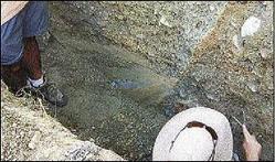
Trench on the east arm of the Morant River showing possible fault or a splay.
The search for sites led to the Serge Island Dairy Farms, an abandoned pasture where a number of river terraces and risers were plain to see. The first trench was dug courtesy of the company who allowed us to use their backhoe for a day. Disappointed that the trenches dug on the farm revealed no relict fault processes, the team moved on to the east arm of the Morant River in the vicinity of the village of Hillside following a flyover of the fault from Morant Bay to Morant Point afforded us by the JDF air wing. Two trenches were dug at this locality using a rented backhoe across what appeared to be the trace or a splay (like a tributary is to a river) of the PGF. Samples of carbon and other sediments were sent for dating and obvious offsets of sediments were noted. Time constraints of team members precluded proper mapping and logging of the trench and trenching at other selected sites. All trenches were back filled with the material removed.
Trenching in Jamaica remains a study to be continued. What happens next will depend on the results of dating the samples collected, the availability of funds and time of the team members, particularly the palaeoseismologist. Other faults on the island worthy of investigation include the Duanvale, Crawle River, Wagwater, Silver Hill, Spur Tree, Santa Cruz and Montpelier faults. Currently, only 316 years of earthquake history for Jamaica is known and this holds just one earthquakes of magnitude greater than seven and two greater than six, not enough to forecast recurrence trends of these damaging events, and what the future might bring. Palaeoseismology could recover perhaps 1,000 years or 10,000 years of earthquake history which when combined with slip rates measured using Global Positioning System and knowledge of current seismicity could provide conclusive results regarding Jamaica's seismic past and future. Members of the team were in alphabetical order, Ms Bryn Benford (PhD student), Dr Charles DeMets (Geophysicist), Omar Josephs (Geologist), Will King (Geology student), Dr Paul Mann (Geologist), Dr Carol Prentice (Palaeoseismologist) and Dr Margaret Wiggins-Grandison (Seismologist).
Margaret D. Wiggins-Grandison, PhD, research fellow/seismologist
Address: Earthquake Unit, 2 Plymouth Crescent, University of the West Indies - Mona campus, Kingston 7
Telephone: (876) 927-2586/935-8249; fax: (876) 977-3575
email: margaret.wigginsgrandison@uwimona.edu.jm.
The MIAS
The MIAS is a non-profit organisation of the University of the West Indies, Pure and Applied Sciences Department, offering analytical, technical and, web services and specialised science projects. If you have any questions or comments about these articles please email : mias@uwimona.edu.jm or contact the MIAS Analytical Services Division at 970-2042 or 512-3067 for enquires on services offered.