Professor Christopher Robinson, Contributor
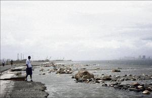
This section of the Palisadoes road was badly damaged during Hurricane Dean. - Contributed photos
On August 31 and September 7, 2006 we wrote two articles on 'The Palisadoes: Safe Access to the Airport?' After looking at the consequences of Hurricane Ivan in 2004, we considered that the Palisadoes road to the Norman Manley International Airport, with all its shortcomings, would remain the most viable and least expensive route to maintain for at least the medium-term future. Now, three years later, we have suffered another fearsome storm that has devastated many parts of Jamaica. Some reports suggest that Hurricane Dean was not as bad as Ivan. Others, including those from Caribbean Terrace, suggest it was much worse. Here, we revisit the Palisadoes.
By the evening of Sunday, August 19, the road to the airport was completely blocked by debris. Thanks to the efforts of the National Works Agency (NWA) access to the airport was re-established by Monday afternoon and normal public access by the following day. Clearly, the NWA was in a much better state of readiness than with Ivan.
To recap a little: following Ivan the power lines to Port Royal were restored. In order to minimise future storm impacts, the wave-deposited sand was piled on the seaward side of the road and became partially vegetated. In July 2005, Hurricane Emily brushed by, producing more debris on the road and reminding us that some intervention was required for road protection. This came in the form of limestone boulders piled on top of a prominent layer of beachrock at one of the more sensitive places along the road.
Dean worse than Ivan
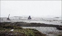
A section of the Palisadoes blocked by sand during Hurricane Dean.
However, a couple of high tides and persistent trade winds caused flooding in two unprotected sections of the roadway in 2006 and reiterated the need for more substantial protection. Earlier this year, a team of Cuban specialists developed a plan to restore the ocean-side beach on the eastern part of the Palisadoes and build revetments that would protect the most vulnerable section of the road. Construction of the first part of the revetment commenced in June 2007, but was incomplete at the time Dean arrived on August 19.
Was Dean worse than Ivan? For Palisadoes, a definite yes. Extensive sand deposits piled up against the rebuilt and re-collapsed wall surrounding the Gypsum Company's stockpile. As we walked the peninsula on the Monday, we noted that the whole eastern end of the Palisadoes was completely flattened; hardly a trace of a sand dune (photo1). Ivan and, probably, Emily had already depleted this part of the Palisadoes of its protective dunes. When Dean arrived its higher surge and waves overtopped the remaining dunes, creating much broader washover channels. Everything was scoured almost down to sea level and whatever remained was pushed into the harbour. This onslaught resulted in exposure of the old water mains and complete destruction of power lines and disappearance of the poles for over a kilometre. The plucking action of the hurricane waves on the leeward (harbour side) had attacked and undermined the roadbed in places.
The remains of the boulder rampart, constructed following Hurricane Emily, were a sad sight. We had indicated, in a letter to The Gleaner on August 31, 2005, and also in our article of August 31 last year, that these boulders were like others we have been mapping around the island, and which have been moved considerable distances during storms. Things proved to be no different here. The rampart was flattened. Some of its boulders had rolled or bounced up to 70 metres across the roadway into the harbour, leaving bounce marks on the road. The road received some of its worst damage at exactly the places where the biggest and most numerous boulders had crossed it (photo 2).
Just past the much reduced remains of the old groynes, built in the 1950s, was the new revetment. This had stood up well to the hurricane. Some boulders at the eastern end had broken loose, but in general it fulfilled its purpose of protecting the road.
Two weeks later on September 3, 2007, Hurricane Felix passed 450 km south of Jamaica, bringing a repeat of the wave activity experienced from Dean. Why did Hurricane Felix cause such havoc far south of the island, Felix was a Category Five storm as it passed Jamaica. The gigantic waves generated by the 160 km/hr winds spread out in all directions, well beyond the focus of the storm itself, and inundated the road yet again. Since then, in calm weather, water has again flooded parts of the road (photo 3).
Threat from rising sea level
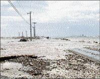
Photo of one of the areas affected by washovers during Hurricane Felix.
So, what is our opinion as regards the future of the Palisadoes road as a secure route to the airport? As expected, the roadbed itself has survived, built as it is on a fairly solid foundation of gravel and beachrock. The revetment being constructed by the NWA will help in protecting the road from surface erosion by storm-delivered debris, as long as the boulders are adequately secured to avoid future road damage. As we suggested a year ago, the medium to long-term threat is from rising sea level. As recent events show, seawater will inundate the road, whether or not there is a protective boulder wall in place. Unless the road level is raised and cambered so as to allow rapid dispersal of flood water, flooding will occur on an annual basis into the future. Sea level has risen some seven centimetres since the early 1970s. This is enough to put parts of the airport road, already nearly at sea level in places, at risk from regular flooding from Trade Wind generated surge and high spring tides, without the intervention of hurricanes. However, with appropriate maintenance, the Palisadoes road will last as long as airliners are likely to keep flying out of Norman Manley Airport.
The Marine Geology Unit
Department of Geography and
Geology
University of the West Indies at Mona
September 18, 2007.
The MIAS is a non-profit organisation of the University of the West Indies, Pure and Applied Sciences Department, offering analytical, technical and, web services and specialised science projects. If you have any question or comments about these articles please email : mias@uwimona.edu.jm or contact the MIAS Analytical Services Division at 970-2042 or 512-3067 for enquires on services offered.